THE SENSORS,
THE DELIVERABLES.
A field‑grade breakdown of every core service sector — the sensor stack we fly, the data each mission yields, and the products that land in your hands. Built for operators who need to know exactly what they're buying before launch.
Solar Farm Security
Autonomous perimeter watch over megawatt arrays — night and day.
A persistent aerial watch over large PV installations. We fly thermal‑optic patrols to detect, classify, and track trespass, theft, and vandalism across sprawling solar sites, with near‑real‑time alerts routed direct to site security.
- Intrusion alert feed with classification + coordinates
- Perimeter breach report and incident timeline
- Thermal‑stamped video evidence chain
- Geofenced incident log (geo‑referenced)
- Weekly security posture summary
Radiometric LWIR — body‑heat detection of intruders in total darkness or low contrast.
HD zoom gimbal with automatic target recognition for person/vehicle classification.
Geofenced mesh link — alerts carry position, classification, and timestamp off‑site.
Drone‑in‑a‑box recharge and relaunch for unattended round‑the‑clock patrols.
Inertial + GNSS track logging for every intrusion event, replayable end to end.
Waterway Mapping
Hydrographic and riparian survey for flood models, habitat, and navigation.
We map rivers, reservoirs, and coastal waterways with a blended aerial and surface sensor stack — producing bathymetric depth models, flood‑plain volumetrics, and riparian habitat maps from a single mobilisation.
- Bathymetric DEM and depth contour model
- Volumetric flood‑plain analysis
- River cross‑section survey sheets
- Georeferenced orthomosaic + riparian habitat map
- Waterway health and erosion risk report
Multibeam / single‑beam sonar (USV‑mounted) for riverbed and reservoir depth profiling.
Aerial photogrammetry for riparian banks, structures, and orthomosaic basemaps.
Centimetre‑grade positioning ties every soundings point to a geodetic frame.
Acoustic Doppler current profiling for flow and discharge measurement where required.
Optical turbidity and water‑quality sensing for environmental condition mapping.
Fire Watch & Mitigation
Early ignition detection and active fireline tracking with auto‑alerts to RFS.
A thermal‑first watch over high‑risk terrain and active firegrounds. We detect ignition hotspots before smoke is visible, track fireline progression, and push automated, georeferenced alerts to emergency services command.
- Hotspot detection grid with lat/long
- Thermal fireline progression map
- Fire‑spread prediction model
- Automated RFS dispatch alert
- Post‑burn severity index
Hotspot detection against a tunable temperature threshold — ignition before smoke.
Multispectral bands tuned to active‑combustion signatures and flame fronts.
HD optical to confirm smoke column, direction, and ground context for command.
On‑station wind and microclimate telemetry feeding spread prediction in real time.
Direct, georeferenced push of hotspot position and severity to RFS dispatch.
Search & Rescue
Thermal contact detection, survivability modelling, and precision supply drops.
Rapid‑deploy SAR support — thermal search of terrain beyond reach of a ground team, survivability modelling to drive search patterns, and precision payload delivery to lost persons. Built for the first 24 hours, when it matters most.
- Survivability model + optimised search pattern
- Thermal contact log with positions
- Last‑known‑position fix report
- Supply‑drop coordinate packet
- Mission debrief and area cleared report
Thermal contact detection of a human signature against terrain, day or night.
High‑power optical zoom to confirm and document a located casualty.
DF on personal locator beacons and mobile transmissions for last‑known fix.
Centimetre‑grade position for drop coordinates and search grid accuracy.
Precision supply drop (water, comms, thermal blanket) and two‑way hailer.
Powerline Monitoring
HV line inspection for thermal faults, clearance, and vegetation encroachment.
Safe, stand‑off inspection of transmission and distribution networks. We fuse thermal, optical, and LiDAR to surface hot joints, clearance violations, and vegetation encroachment — per‑pole, per‑span, without a truck roll.
- Fault hot‑spot report (per pole)
- Clearance violation map
- Vegetation encroachment report
- Asset condition register
- Georeferenced line orthomosaic
Hot‑joint and connector fault detection across connectors, insulators, and splices.
Line‑to‑vegetation and line‑to‑ground clearance measurement in millimetres.
HD pole‑level inspection imagery for asset condition and damage register.
UV corona detection for failing insulators and arcing components.
Multispectral growth mapping to prioritise vegetation management crews.
Solar Panel Inspection
Utility‑scale PV inspection for cell defects, string faults, and yield loss.
Fast, non‑contact inspection of megawatt PV arrays. We fly thermal and multispectral sensors at panel‑level resolution to find hot cells, string faults, and soiling — and turn it into a prioritised maintenance list and a yield report.
- Panel‑level defect map
- Underperformance string report
- Soiling and IV‑curve analysis
- Prioritised maintenance list
- Capacity and yield / ROI report
Panel‑level thermal IR for hot cells, bypass‑diode failures, and string outages.
Electroluminescence‑proxy bands for cell‑level defect and degradation mapping.
High‑res array basemap for panel indexing and damage documentation.
On‑board irradiance reference so thermal results normalise to weather at the fly.
String‑grouped thermal to isolate inverter and combiner faults quickly.
Wind Turbine Monitoring
Autonomous, repeatable blade and tower inspections flown with no pilot on site.
Stand‑off inspection of onshore and offshore wind assets flown on automated, pre‑planned missions. We capture blade, tower, and nacelle data with optical, thermal, and LiDAR sensors along repeatable flight paths — so every survey is identical to the last and defects are measured against a moving baseline, not a guess.
- Automated blade‑surface defect map (per blade)
- Thermal nacelle / gearbox anomaly report
- Blade‑profile and tower‑plumb LiDAR model
- Repeatable mission path — identical pass every cycle
- Trend baseline and asset‑health scorecard
High‑res gigapixel imaging of leading edge, trailing edge, and root for surface and lightning damage.
Nacelle and gearbox thermal survey to flag bearing, brake, and electrical hotspots early.
Millimetre blade‑profile and tower‑plumb measurement via repeatable RTK‑locked flight lines.
Drone‑in‑a‑box launch, charge, and relaunch for scheduled unattended turbine patrols.
On‑station microclimate and yaw telemetry logged against each pass for trend analysis.
CHOOSE THE
RIGHT AIRCRAFT.
Seven DJI aircraft platforms across thermal, LiDAR, and orthomosaic-structural mapping — plus the DJI O4 Ground Station for wide-area BVLOS command — staged through DJI Dock hangars for autonomous launch, charge, and relaunch. Brief your requirement and request the platform that fits the mission.

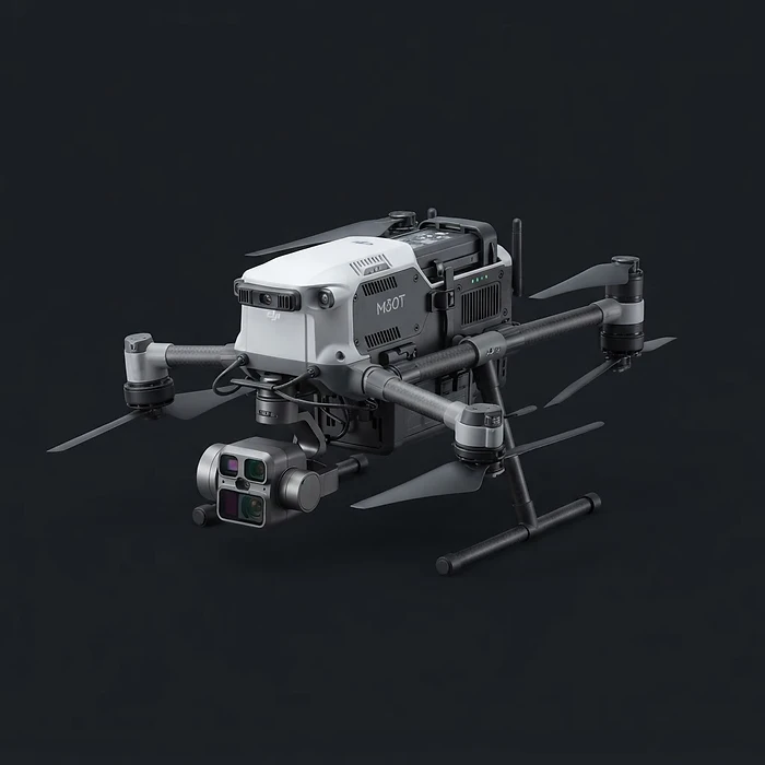
- HANGAR
- DJI Dock
- FLIGHT TIME
- 41 min
- PAYLOAD
- Thermal / Zoom / Laser Rangefinder
Fire watch, security patrol, powerline faults, emergency deploy
REQUEST DJI Matrice
